Streamline Planning
Improve your planning, reports, and bid process with rapid, accurate & precise, and cost-effective drone data
Optimize Project Management
Eliminate project waste and extra useless expenses with full-site awareness using regular, shareable site maps
Minimize Risks
Track every step of the construction process for years – even across multiple owners
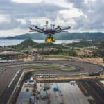
Civil engineering is one of the industrial branches which needs very precise data, a few centimeters at most, but our equipment goes beyond expectations, since the measurement accuracy of our Lidar is 1 cm and our geo system -positioning and trajectory correction allows GPS positioning accuracy up to 1.3 in optimal conditions. Thus, we can provide plans for any type of civil engineering project: bridge construction, city and road design, advanced building construction, highway planning, development of transport such as airports and port area.
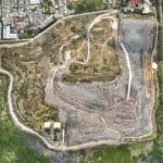
Save time, improve communication, and reduce cost by using drone data to perform surveys, conduct inspections, and document every job site. Our engineers are able to work on projects of private companies or the public sector. Our different files like point cloud, DEM and DSM, Digital terrain model (DTM), contour line scan be imported in your BIM software. Also, We provide of course Orthoimagery (2D map) files like tiff or kmz.
The contour line maps represent the level lines very precisely at regular intervals, defined during the export. The intervals represent the variations in orthometric heights of the earth’s surface. This data set therefore makes it possible to represent the elevation and altitude of a terrain or an area. With our drone services, it has never been easier to acquire this type of data, even for large areas because our UAVs can cover and map several hundred hectares per day, unlike conventional surveys which require weeks or even months for the same area.
Example of drone civil engineering application
- Aerial surveying & 3D mapping
- Asset & infrastructure inspection
- Building Construction / Renovation
- City Design
- Risk Analysis
- Track progress
- Site Modeling
- 3D site visualization
- Site Planning
- Map generation DTM, DSM, DEM
- Bridge Construction
- Highway Planning / Construction


