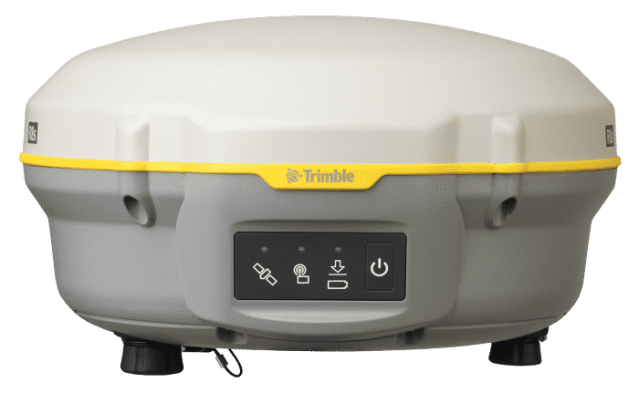
Trimble R8S LT

Trimble R8s GNSS RécepteurConfiguré pour aujourd'hui, évolutif pour demain
La solution complète – Le Trimble R8s offre le summum de l’évolutivité. Au fur et à mesure que vos besoins changent, le Trimble R8s LT peut s’adapter. Ajoutez simplement des fonctionnalités chaque fois que vous en avez besoin. Créez une solution de terrain de pointe en associant le récepteur GNSS Trimble R8s à un puissant contrôleur Trimble chargé avec notre logiciel de terrain Trimble Access facile à utiliser.
Plus qu’un système préconfiguré, le système GNSS Trimble® R8s LT vous offre les fonctionnalités et les avantages dont vous avez besoin. Dans un système flexible et évolutif. Il n’a jamais été aussi facile de créer un système adapté à votre travail.
Le Trimble R8s LT s’intègre facilement aux stations totales Trimble S-Series et au mobile d’imagerie Trimble V10 innovant. Créez une solution complète en combinant le récepteur Trimble R8s LT avec un contrôleur Trimble exécutant le logiciel de terrain Trimble Access ™ et le logiciel de bureau Trimble Business Center.
Avec le Trimble R8s LT, il est facile et simple de construire un récepteur adapté au travail. Choisissez le niveau de configuration qui correspond le mieux à vos besoins, qu’il s’agisse de post-traitement, de base, de mobile ou d’une combinaison de fonctionnalités de base et mobile. Après avoir sélectionné un niveau de configuration, des options individuelles supplémentaires peuvent être ajoutées pour étendre davantage la fonctionnalité du récepteur.
Principales caractéristiques
- Double fréquence et possible configuration en Rover
- Disponible dans les configurations de post-traitement, de base uniquement, de rover uniquement ou de base et rover
- Suivi de satellite avancé avec la technologie de réception Trimble 360
- Comprend une puce Trimble "Maxwell 6" avec 220 canaux
- Intégration simple avec les stations totales Trimble S-Series et le V10 Imaging Rover
- Logiciel intuitif Trimble Access Field et logiciel Trimble Business Center Office
- Application mobile Trimble - une nouvelle façon de collecter rapidement des données RAW GNSS

PRIX DE LOCATION
Simple Base/Rover
Pack complet
Double Base + Rover
Simple Base/Rover
Pack complet
Double Base + Rover
SPÉCIFICATIONS DE PERFORMANCE
Mesures
- Advanced Trimble Maxwell 6 Custom Survey GNSS chip with 220 channels
- Future-proof your investment with Trimble 360 tracking
- High precision multiple correlators for GNSS pseudo-range measurements
- Unfiltered, un-smoothed pseudo-range measurements data for low noise, lowmultipath error, low time domain correlation, and high dynamic response
- Very low noise GNSS carrier phase measurements with <1 mm precision in a 1 Hzbandwidth
- Signal-to-Noise ratios reported in dB-Hz
- Proven Trimble low elevation tracking technology
- Satellite signals tracked simultaneously:
- GPS: L1C/A, L1C, L2C, L2E
- GLONASS: L1C/A, L1P, L2C/A, L2P
- SBAS: L1C/A
- BeiDou (COMPASS): B1, B2
- SBAS: WAAS, EGNOS, GAGAN
- Positioning rates: 1 Hz, 2 Hz, 5 Hz, and 10 Hz
PERFORMANCE DE POSITIONNEMENT
Positionnement différentiel du code GNSS
Horizontal ……………………………………………… 0.25 m + 1 ppm RMS
Vertical ……………………………………………….. 0.50 m + 1 ppm RMS
SBAS differential positioning accuracy …………………….. typically < 5m 3DRMS
Static GNSS surveying
High-Precision Static
Horizontal ………………………….. 3 mm + 0.1 ppm RMS
Vertical ………………………………………… 3.5 mm + 0.4 ppm RMS
Static and Fast Static
Horizontal ………………………………………….. 3mm + 0.5 ppm RMS
Vertical …………………………………………….. 5 mm + 0.5 ppm RMS
Post processed Kinematic (PPK) GNSS surveying
Horizontal……………………………………………….8mm+1ppmRMS
Vertical ………………………………………………..15mm+1ppmRMS
Real-Time Kinematic surveying
Single Baseline <30 km
Horizontal ………………………………………………. 8mm + 1 ppm RMS
Vertical ……………………………………………… 15 mm + 1ppm RMS
Network RTK
Horizontal ………………………………………….. 8mm + 0.5 ppm RMS
Vertical ……………………………………………. 15 mm + 0.5 ppm RMS
Initialization time …………………………………….. typically <8 seconds
Initialization reliability …………………………………….. typically >99.9%
ÉLECTRIQUE
- Power 10.5 V DC to 28 V DC external power input with over-voltage protection on Port 1 (7-pin Lemo)
- Rechargeable, removable 7.4 V, 2.8 Ah Lithium-ion smart battery
- Power consumption is <3.2 W in RTK rover mode with internal radio and Bluetooth® in use
- Operating times on internal battery8:
- 450 MHz receive only option …………………………………. 5.0 hours
- 450 MHz receive/transmit option (0.5W) ……………………… 2.5 hours
- Cellular receive option ………………………………………. 4.0 hours
COMMUNICATIONS ET STOCKAGE DE DONNÉES
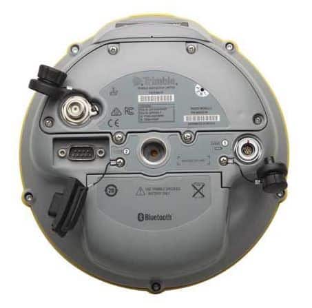
- Serial: 3-wire serial (7-pin Lemo) on Port 1; full RS-232 serial (Dsub 9 pin) on Port 2
- Radio Modem: fully Integrated, sealed 450 MHz wideband receiver/transmitter with frequency range of 403 MHz to 473 MHz, support of Trimble, Pacific Crest, and SATEL radio protocols:
- Transmit power: 0.5W
- Range : 3–5 km typical / 10 km optimal
- Cellular : fully integrated, sealed internal GSM/GPRS/EDGE/UMTS/HSPA+ modem option. CSD (Circuit-Switched Data) and PSD (Packet-Switched Data) supported. Global Operation:
- Penta-Band UMTS / HSPA+ (850 / 800, 900, 1900, and 2100 MHz)
- Quad-Band GSM/CSD & GPRS/EDGE (850, 900, 1800, and 1900 MHz)
- Bluetooth: fully integrated, fully sealed 2.4 GHz communications port (Bluetooth)
- External communication devices for corrections supported on Serial and Bluetooth ports
- Data storage: 56 MB internal memory, 960 hours of raw observables (approx. 1.4 MB/day), based on recording every 15 sec from an average of 14 satellites
Data Formats
- CMR+, CMRx, RTCM2.1, RTCM2.3, RTCM3.0, RTCM3.1 inputs and outputs
- 23 NMEA outputs, GSOF, RT17 and RT27 outputs, supports BINEX and smoothed carrier
WebUI
- Offers simple configuration, operation, status, and data transfer
- Accessible via Serial and Bluetooth Supported Trimble Controllers
- Trimble TSC3, Trimble Slate, Trimble CU, Trimble Tablet Rugged PC
Certifications
FCC Part 15 (Class B device), Part 15.247 and Part 90 ; ICES-003, RSS-210 and RSS-119; CE Mark; C-Tick; Bluetooth EPL

